


roc marchant

whisper73
User
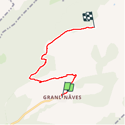

Length
5.3 km

Max alt
2088 m

Uphill gradient
767 m
Km-Effort
13 km

Min alt
1328 m

Downhill gradient
12 m
Boucle
No
Creation date :
2015-06-26 00:00:00.0
Updated on :
2015-06-26 00:00:00.0
1h43
Difficulty : Easy

FREE GPS app for hiking
 SityTrail
IGN / Geographical institutes
SityTrail Plus
The world is yours!
About
Trail Walking of 5.3 km to be discovered at Auvergne-Rhône-Alpes, Savoy, La Léchère. This trail is proposed by whisper73.
Positioning
Country:
France
Region :
Auvergne-Rhône-Alpes
Department/Province :
Savoy
Municipality :
La Léchère
Location:
Naves
Start:(Dec)
Start:(UTM)
306655 ; 5048099 (32T) N.
Comments